Wagg Creek at footbridge below sedimentation pond - WAG-M-03 Medium Priority
North Vancouver, British Columbia, Canada
WAG-M-03 WAG Creek at footbridge below the sedimentation pond at the fish ladder. CNV City Map CNV City Map -123.0777490, 49.32733712 Long and Lat, or UTM 494,351E, 5,463,848N. Identical to Salt Project site "Wagg Creek Fish Ladder and Pond at Mahon St". Merge data into this new location or archive old data?

- Site ID: WAG-M-03
- Lat: 49.3272058
- Lng: -123.0778384
- Waterbody Type: Creek
- Timezone: America/Vancouver
Latest photos
View all photosCrayfish and stickleback observed. Turbidity < 14 NTU. ALS Global sampling 6PPD and Q
Turb < 14
No flows done
Turbidity <14
Looking very clear today
Turbidity less than 14.
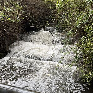
Tested due to Paul's report of blackish water downstream at 10:20. Black water observed in the pond and below it, but turbidity normal (even in the pond itself). Black water seemed to be concentrated on the east side of the pond (inflow side from E06A rather than inflow side from W03) but this may have been an artifact of the greater depth on that side. Minor foaming.
Turbidity <14
Turbidity <14
Turbidity less than 14
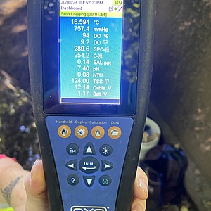
YSI simultaneous measurements
Did not sample oxygen this morning, couldn't safely get closer than the edge due to strength of flow. Looks pretty aerated though :D
Big dead fish from yesterday not visible - uncertain if it was covered by water, washed downstream, or eaten by a raccoon.
Less than 14
Rain had stopped when we arr at this site.
YSI measurements taken simultaneously.
Secchi disk just discernable at 14 NTU; turbidity is <14, but had brownish cast and appeared more slightly more turbid than water at WAG-O6a measured in the same session.


