Arm Lake
Saskatchewan, Canada
Private dock at Stinson acreage at the bottom of a small wooded coulee with native prairie on either side. Water is still. Water drops off quickly further out where the old river channel used to be before the dam was built.

- Group: University of Regina : Citizen Science
- Lat: 51.0671019
- Lng: -105.802846
- Waterbody Type: Lake
- Timezone: America/Regina
Latest photos
View all photos--- BBCODE ---
[URL=https://google.com/]google[/URL]
[url=https://google.com/]google[/url]
--- RARE ---
[link=https://google.com/]google[/link]
[link name=google]https://google.com/[/link]
((https://google.com/))
((https://google.com/ google))
[https://google.com/ google]
[[https://google.com/ google]]
[L=google]https://google.com/[/L]
"google":https://google.com/
[google](https://google.com/)
Air temperature reading changed from 20.0°C to -6.7°C and water temperature reading of 20.0°C and hardness reading of 5.2 mg/L both removed by admin (jonas@waterrangers.ca)
Air temperature reading changed from 20.0°C to -6.7°C and water temperature reading of 20.0°C and hardness reading of 5.2 mg/L both removed by admin (jonas@waterrangers.ca)
Air temperature was -5C, but I couldnt enter a negative on my phone
A couple small flocks of snow geese flew overhead while testing. Some animal tracks in the snow (coyote, mice, rabbits)
Air temperature changed to -5°C by admin
Fish jumping, ducks in area
Note: unsure of test kit with "Nitrate/N" key vs the flipside of "Nitrate", and a previous field here that was nitrite. In our testing, the Nitrate/N was 0.2 (or slightly pinker than 0.2 but not as pink as the next, 0.5 level. The Nitrate side was >1
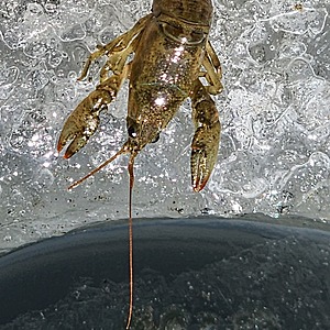
Crayfish and gammerus collected and released at water testing site (from under a rock)
The water in the immediate area was opaque with algae and surface scum. The shore had a wide matt of blue-gtreen algae. Visibility was essentially zero. If the surface scum was disturbed by raising and lowering the disk, visibility rached 10cm. The next day though, a change in wind direction made it possible to view to the bottom (54 cm), although still contained significant numbers of algae strands throughout the visible water column.
Birds included pelicans soaring, and purple martins calling
Nitrates test: 0
Phosphates: 0
Lots of minnow activity around the dock (100s per m3)
Many mosquitoes
Various birdsong: tree swallow, yellow warbler, American goldfinch (ID assisted with Merlin app)
Nesting crow nearby and could hear the juveniles as well as the adults
9 pelicans flew by, low on the water.
pH meter was not calibrated prior to testing
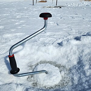
Distance to bottom was 80 cm, with 76 cm of ice (only 4 cm of water in the location we drilled, a bit further out than the usual end of dock location, where the ice reached the muddy bottom.
No visible green algae!
Some small crayfish were accidentally brought to the surface at the first hole attempted, which struck the muddy bottom.
People ice fishing further north on the lake have been catching fish, despite the low oxygen level.
-pH meter was not working properly, so no pH recorded.
-8 inch secchi disc did not fit in 6 inch hole, so measured depth to bottom with a stick


