Sellers Creek
Mendenhall, Mississippi, United States
Site is located on Hwy 149 between Mendenhall and DLo 0.7 miles west-northwest from the intersection of the Hwy 13 exit ramp and Hwy 149 to the Sellers Creek bridge. From Hwy 49 traveling south, take the Hwy 13 south exit for Mendenhall. Take the right exit ramp off Hwy 13 to the intersection of Hwy 149, then turn right on Hwy 149. A small asphalt pad suitable for parking is located on the right side of Hwy 149 immediately before Sellers Creek bridge guardrail and just past a gated gravel track that intersects the highway. The pad provides just enough room for parking a single vehicle, though it is close to the edge of the highway. Walk across the highway then down the open ROW to the edge of the creek that, relative to the bridge, is on the right upstream edge. The highway ROW appears to be mowed, maintained, and there are tire tracks in the dirt where it seems some people might drive to the creek. If the creek bank edge is too steep depending water depth, walk under the bridge through the bridge pilings to the right downstream edge of the creek. There are some granite rip-rap rocks on the right downstream edge of the creek under and on the edge of the bridge. This site represents a downstream location from the Mendenhall sewer lagoon outfall to Sellers Creek and Mendenhall, relative to the upstream Sellers Creek site on South Main Street in Mendenhall. This Hwy 149 site may provide a comparison to the upstream Sellers Creek South Main site. The Hwy 149 site also may provide insight to water quality influences at the downstream DLo water park site on the Strong River. From the Hwy 149 Sellers Creek bridge, Sellers creek flows about 0.3 mile to the confluence of the Strong River located just upstream from DLo water park.

- Group: Mississippi State University : Mississippi Water Stewards
- Lat: 31.9724604
- Lng: -89.893055
- Waterbody Type: Creek
- Timezone: America/Chicago
Latest photos
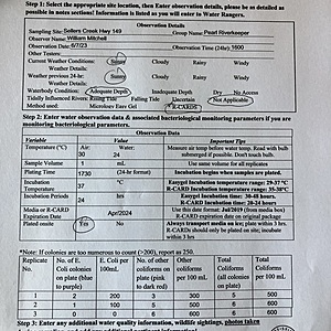
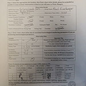
View all photosToo many colonies to count on all cards. Extrapolated by counting a few squares, would have been in excess of 300 for both blue and red.
Creek running up about 1 foot due to recent rain, relative to typical summer flow.
Hwy bridge construction continuing just downstream from test site.
**Samples taken upstream from bridge work
Construction on new Hwy 149 bridge continuing. Sample location site still located just upstream of new bridge. Construction still not expected to change concentration of E. coli or other coliforms.
Construction continuing on Hwy 149 bridge and hiway.
construction on highway and new bridge continuing............
construction for new hiway and bridge continuing. Test site located 30 feet upstream of temporary bridge. Typical low summer flows.
hwy construction for replacement bridge at test site continuing. Creek running at typical summer low without recent rain. Temporary bridge currently over creek at test site.
Construction has removed the old bridge, for bridge replacement, that is located just downstream of the test site - -located upstream. Bridge construction at this time does not appear to affect the test site stream data.


