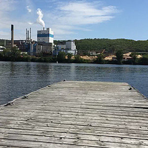
Ottawa River
Témiscaming, Ontario, Canada
Across from Rayonier Advanced Materials. Brown colored water, very hard to see.

- Group: Kipawa Lake Preservation Society
- Lat: 46.7078967
- Lng: -79.101069
- Waterbody Type: River
- Timezone: America/Toronto
Latest photos
DO fluctuated between 12 and 80
Location is approximate
Ottawa River near Long Sault Island (Tembec Island)
Near bridges at Ontario/Quebec border
Active construction on bridge
DO probe changed two weeks ago
Location is approximate, labelled as 'Tembec Island' near boat launch
Pulp and paper mill (Tembec) and boat launch nearby
Tembec (pulp and paper mill) nearby
Lots of spiny water flea at this location
Lots of construction in the area
Conductivity recorded as 774.1 but units were not recorded, previous data sheets had units as mmHg this reading is suspect so it was not included. It is likely the barometric pressure.
Secchi disc reading likely isn't accurate due to flowing water
Site is at a boat launch, right in front of Tembec (pulp and paper mill), heavy shoreline destruction. Water appears brown, two bridges close by.
Conductivity value and units don't make sense - recorded as 744.3 mmHg. It is more likely the barometric pressure.
