Pelahatchie Bay
Brandon, Mississippi, United States
Watercraft launch to the inlets of Pelahatchie Bay and Pelahatchie Creek. Calm water with wetlands. Baypoint Golf Course, fishing, bird watching, boating and other recreational activities. Test from the boat ramp at the Fishing Pier parking lot, not at the Pelahatchie Bay Trading Post.

- Group: Mississippi State University : Mississippi Water Stewards
- Site ID: PC
- Lat: 32.3896015
- Lng: -89.9684572
- Waterbody Type: Bay
- Timezone: America/Chicago
Latest photos
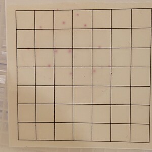
View all photos40+ other coliforms on each RCARD
RCARDs expiration date: 03/18/26
Data entered reflect RCARDs with expiration date of 08/08/25, which are from the lot I've been using this year.
I also tested with new RCARDs with an expiration date of 03/18/26. The results from these cards: 0 E. Coli with 'other coliforms' 2000, 2500, and 2900.
All RCARDs were reviewed and colonies counted within 25 hours, and cards were re-reviewed the next day to determine whether the elapsed time made any difference in color, size, or frequency of coliform results. Aside from the original count difference, there is no discernible difference in any of the other variables between the RCARDs; therefore, I plan to continue using the older cards until the supply is extinguished.
A man was foraging for wild berries when I arrived; last pic is of the berry patch (between parking lot and walking pier).
There have been wide daily temperature swings with a lot of wind.
A fisherman reported seeing two chickens wandering around near the water. I saw one chicken while testing.
Part of the tree to the left of the walking bridge/pier has broken off and dropped branches in front of path to bridge.
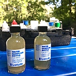
Water was cloudy and brown.
Weather has been cooler this week with cloud cover and rain anticipated; sprinkles of rain have occurred for moments, but no substantial rain.
1st time using the new RCARDs (R-CARD ECC-A, 3 mL, exp 06/05/25)


