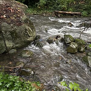
WAG-M-02 Wagg Creek above confluence with Mission Creek. Medium Priority
North Vancouver, British Columbia, Canada
WAG-M-02 Wagg Creek - just above Mission junction. Most easily accessed from the footbridge over Mission Creek just above the confluence. Walk easterly from that bridge along the contours to Wagg. GPS field coordinates Long -123.087723 Lat 49.321832 or UTM E 493,625, N 5,463,237. Must sample well below WAG-E-03 so the waters are well mixed

- Site ID: WAG-M-02
- Lat: 49.322199
- Lng: -123.0877334
- Waterbody Type: Unknown
- Timezone: America/Vancouver
Latest photos
View all photos<14 turbidity
ALS sampling 6PPP and 6PPD-Q
last stop for Josh and Carolynne; the rest of us (4) continue
Turbidity <14
Turb < 14
YSI measurement taken
Turbidity <14 NTU
YSI data collection simultaneously
Turbidity less than 14
measurements taken with YSI. Water flowing clear, turbidity is <14 NTU.
Note lack of tree canopy over the site; stream is exposed to lots of sunlight.
noticeable turbidity and foam in the the creek
Chloride reading of 0 ppm changed to chlorine by admin (jonas@waterrangers.ca)


