Mundy Lake
Coquitlam, British Columbia, Canada
The test area is the south-west side of Mundy Lake; approximately 50 m north of the Mundy Creek outflow.
There is a very slow, visible flow south , it has natural debris on the surface, there is no algae, tea water colour, clear clarity, no odour. Vegetation such as moss, lady fern, cedar trees, bushes such as huckleberry and salal are right at the edge of the water. Western pond lilies are present on the surface at the lake, but not at the testing site. Submerged tree fall is present in the lake and near the testing site. The ground adjacent to the lake is boggy. Bears can be present in the park.

- Group: Burke Mountain Naturalists
- Site ID: 49.25759 N, 122.82923 W
- Lat: 49.2573442
- Lng: -122.829423
- Waterbody Type: Lake
- Timezone: America/Vancouver
Latest photos
View all photospollen, some lily pads present, leaves, seeds, pollen on surface
15 dragon flies (blue, 1 with 2 white stripes). 1 American bullfrog
Insects swarming
3 American robins. 2 brown creepers
3 song sparrows 3 chestnut backed chickadees
1 hutton's vireo 1 Northern flicker
3 Swainson's thrush
2 Pacific sloped flycatcher
Purple Finch
Chestnut Backed Chickadee
Pacific Sloped Flycatcher
Warbling Vireo
Song Sparrow
Black throated Grey Warbler
1 pair ring necked ducks
pine siskin
spotted towhee
song sparrow
song sparrow
pine siskin
spotted towhee
1 pair ring necked ducks
pacific wren
song sparrow
pine siskin
raven
yellow rumped warbler
purple finch
Merlin app: northern saw-whet owl
Ice on surface of lake but sample site free of ice
branches on surface of water
Trail flooded (NW corner of lake)
Song sparrow, spotted towhee, American robin, pacific wren, golden crowned kinglets heard
thin ice (0.6 cm) at sampling site (we had to break the ice to obtain our sample)
Canada geese heard flying overhead
Flooding of trails
pH reading obtained using NEW pH strips utilizing Hydrion plastic pH indicator strips 0.0-6.0 obtained from Granger Canada (previous pH readings obtained using water rangers Taylor pH strips 6.4-8.4, and the pH readings were not registering on the strips (always below 6.4))
No bird life heard or observed this morning
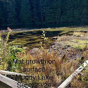
Less algae/mat growth on surface at other locations on the lake than previously noted
Very high water level, trails flooded, atmospheric river 8 days ago
Surface mat of algae growth observed on surface of lake in other locations (not at sampling site)
pH reading obtained with BCIT Hanna combo pen pH meter: 4.92
BCIT Hanna oxygen meter dissolved oxygen reading meter: 73 % (6.57 mg/L)
Our dissolved oxygen comparator vials expired in Sept./2024.


