Pearl River
Picayune, Mississippi, United States
Boat ramp.

- Group: Mississippi State University : Mississippi Water Stewards
- Lat: 30.5704421
- Lng: -89.7882128
- Waterbody Type: River
- Timezone: America/Chicago
Latest photos
View all photosRiver has been at near flood stage frequently, more turbid than usual, more visible particulate than usual.
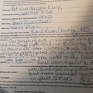
We chose this site because it was accessible, safe and close to our new home. Our first visit was during a period of record rainfall, the Pearl (we are sampling on the East branch) was at flood stage. Waters cam halfway up the boat launch.
We spoke with 3 local residents who told us the "normal" levels were not high enough to launch a boat. We later found out that in the 1990s, a weir was built to divert more water to the East Pearl. The flow was about 85/15 at its best. The weir is now failing, and no agency or organization at local, state federal level are willing to get involved. We believe with the "One Lake" project's green light , this site will no longer be valid.
Record breaking rains in August, with the Pearl Cresting above flood levels. Walkiah Bluff hit hit 39.6 feet on 9/10, dropped 9/11Adequate depth, not tidally influenced


